Gerald Galgana1,2, Michael Hamburger1, Robert McCaffrey3, Ernesto Corpuz4 and Qizhi Chen1
1Department of Geological Sciences, Indiana University, Bloomington, Indiana 47405 USA
2Manila Observatory, Loyola Heights, Quezon City, Metro Manila, Philippines
3Department of Earth and Environmental Sciences, Rensselaer Polytechnic Institute, Troy, New York 12180 USA
4Philippine Institute of Volcanology and Seismology, UP Campus, Diliman Quezon City Philippines
 |
| Gerald Galgana |
 |
| Robert McCaffrey |
 |
| Michael Hamburger |
Plate boundary zones are fundamental to the understanding of interactions between tectonic plates, as these broad zones of deformation account for the most of the world’s interplate tectonic activity (e.g., Stein and Sella, 2002; Kreemer et al., 2003). Furthermore, plate boundary zones associated with oblique subduction (for example in Sumatra in the Indonesian arc, and in the North Island of New Zealand) are characterized by extensive strike-slip faulting, high seismicity, rapid vertical axis rotations and extensive intraplate deformation in the overlying plate (Fitch, 1972; McCaffrey, 2002; Wallace et al., 2004).
Luzon is situated in a Plate Boundary Zone (PBZ), an actively deforming region where earthquakes and tectonic motion are prevalent (Figure 1). These are direct consequences of rapid convergence between the Philippine Sea Plate and the Sundaland Plate (part of the Eurasian Plate) along dual, opposing subduction in the Manila Trench (western margin), and along the East Luzon Trough-Philippine Trench (eastern margin). In addition to these features, strike-slip faulting also occurs along the NW-SE-trending Philippine Fault System and the Verde-Passage/Sibuyan Sea Fault. Extensive faulting and deformation is also observed in southwestern Luzon, along the Marikina Fault System and the Macolod Corridor.
Plate boundary zones have been modeled using simple fault-bounded plate boundaries (e.g., Morgan, 1968), half-space elastic models, complex multi-layered elastic-viscoelastic models (e.g., Thatcher 1995), and a series of subparallel faults and crustal blocks (e.g., Bennett et al., 1996). The fault-and-block system essentially describes zones of deformation as being comprised of a set of finite, elastic blocks, separated by discrete faults, basically a small-scale analog to the global model of plate tectonics. In this study, we use precise campaign Global Positioning System (GPS) measurements and earthquake focal mechanisms to characterize tectonic deformation in Luzon Island, Philippines. GPS uses trilateration techniques or distance measurements of receivers relative to orbiting satellites to determine the location of receivers on the earth’s surface. Distances obtained from several GPS satellites enable accurate determination of global coordinates at the receiver’s location. Multiple (campaign-style) observations of receivers stationed on survey reference points (triangulation stations or benchmarks) give the change in location at specific time intervals, giving hints to tectonic block velocities. This happens after determining geodetic-quality or millimeter-level accuracy of positions of benchmarks from post-processing techniques. Earthquake focal mechanisms, on the other hand, give relative (plate) directions of motion due to seismic events (Dziewonski et al., 1981). These are obtained from waveforms of earthquakes in a specific region. We utilize positional data (1996-2002) from 56 stations in Luzon and Southeast Asia, and combined these with slip vectors from 78 earthquake events within the period 1977-2003.
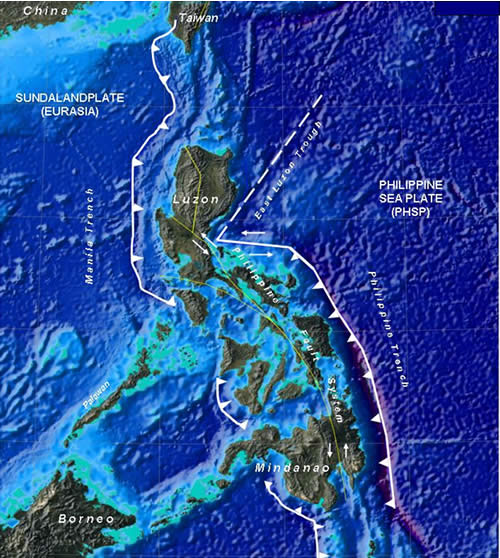 |
| Figure 1. Tectonic setting of the Philippine Islands. Deformation in this seismically active region is primarily due to the westward subduction of the Philippine Sea Plate along the Philippine Trench and East Luzon Trough, and eastward subduction of the Sundaland Plate along the Manila Trench. Extensive strike-slip faulting is also evident along the Philippine Fault System and its associated splays. From Galgana et al., 2007. |
Processed satellite imagery and digital elevation models (used together with existing gravity anomaly, seismicity, and geologic maps) are initially used to define a suite of seven elastic tectonic blocks. Then, block velocities inferred from GPS observations as well as earthquake slip vectors (from the Harvard Centroid Moment Tensor [CMT] Catalog) are combined in an inversion process to constrain tectonic block velocities and rotations as well as to obtain estimates of slip and locking strain along major faults. High coupling or locking estimates along faults and subduction zones give indications of strong earthquake probabilities due to elastic rebound.
Major tectonic structures that were found to absorb the plate convergence include the Manila Trench (20-100 mm yr-1) and East Luzon Trough (~9-15 mm yr-1)/Philippine Trench (~29-34 mm yr-1), which accommodate eastward and westward subduction beneath Luzon, respectively; the left-lateral strike-slip Philippine Fault (~20-40 mm yr-1), and its northward extensions, the Northern Cordillera Fault (~17-37 mm yr-1 transtension), and the Digdig Fault (~17-27 mm yr-1 transpression). These slip rates are comparable with that of active strike-slip faults in the world such as the San Andreas Fault in California, and the Southern Alpine Fault in New Zealand. The Macolod Corridor, a zone of active volcanism, crustal thinning, extension, and extensive normal and strike-slip faulting in southwestern Luzon, is associated with left-lateral, transtensional slip of ~5-10 mm yr-1. The Marikina Fault, which separates the Central Luzon block from the Southwestern Luzon block, reveals ~10-12 mm yr-1 of left-lateral transpression.
Our results infer that the northern Philippine Fault is almost fully locked while its associated splays in southern Luzon are partly coupled, while the Manila and Philippine trenches appear to be poorly coupled. The Marikina Fault, the Northern Cordillera Fault, Digdig Fault and the Verde Passage Fault are almost fully locked to highly coupled. Locking depth estimates based on the inversions reveal a 25-kilometer deep seismogenic crust near the Philippine Fault system. Overall, Luzon is best represented as a tectonically active plate boundary zone, with six mobile elastic tectonic blocks situated between two active subduction zones (Figure 2). The Philippine Fault and associated intra-arc faults accommodate much of the trench-parallel component of relative plate motion.
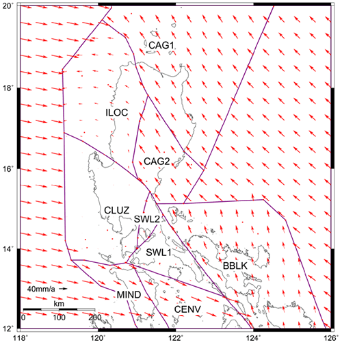 |
| Figure 2. The preferred Luzon block model. This best-fit model consists of six mobile elastic blocks with varying rates of rotation and fault locking strain along boundaries. Red arrows indicate the rates of motion (From Galgana et al., 2007). |
References:
*Galgana, G., M. Hamburger, R. McCaffrey, E. Corpuz and Q. Chen. 2007. Analysis of Crustal Deformation of Luzon Island, Philippines using Geodetic Observations and Earthquake Focal Mechanisms, Tectonophysics 432:63-87.
Bennett, R., Rodi, W., Reilinger, R., 1996. Global Positioning System constraints on fault slip rates in southern California and northern Baja, Mexico. Journal of Geophysical Research 101(B10) 21,943-21,960.
Dziewonski, A.M., Chou, T.-A., Woodhouse, J.H., 1981. Determination of earthquake source parameters from waveform data for studies of global and regional seismicity. Journal of Geophysical Research 86, 2,825-2,852.
Fitch, T.J., 1972. Plate convergence, transcurrent faults and internal deformation adjacent to southeast Asia and the western Pacific. Journal of Geophysical Research 77, 4,432-4,460.
Kreemer, C., Holt, W., Haines, J., 2003. An integrated global model of present-day plate motions and plate boundary deformation. Geophysical Journal International 154(1): 8-34.
McCaffrey, R., 2002. Crustal Block Rotations and Plate Coupling. In “Plate Boundary Zones”, eds. Seth Stein and Jeffrey Freymueller, AGU Geodynamics Series, Vol. 30.
Morgan, W.J., 1968. Rises, Trenches, Great Faults and Crustal Blocks. Journal of Geophysical Research 73, 1959.
Stein, S., Sella G., 2002. Plate Boundary Zones: Concept and Approaches. Plate Bounday Zones. In “Plate Boundary Zones”, eds. Seth Stein and Jeffrey Freymueller, AGU Geodynamics Series 30, 1-26.
Thatcher, W., 1995. Tectonic block versus continuum description of active tectonic deformation. Journal of Geophysical Research 100(B3), 3,885-3,894.
Wallace, L., Beavan J., McCaffrey R., Darby D., 2004. Subduction Zone Coupling and Tectonic Block Rotations in the North Island, New Zealand. Journal of Geophysical Research 109, B12406, doi:10.1029/2004JB003241.
__________
Gerald A. Galgana is a geodetic engineer and geodesist-geophysicist. He obtained his BS degree in Geodetic Engineering from the University of the Philippines in Diliman, Dipl. R&D Management at the University of the Philippines Open University, and MS Geophysics at Indiana University. He is presently a PhD candidate at Indiana University in Bloomington, Indiana, specializing in geodesy and geophysics. His fields of interest include plate tectonics, geodesy and geodynamics, geophysical signal/image processing and deconvolution, microwave and multispectral remote sensing and geodetic applications on volcano deformation. His present areas of study include Philippine tectonics, active volcanism in Taal, and intraplate deformation within the United States’ mid-continent along the Wabash Valley fault system. He can be reached via e-mail at ggalgana[@]indiana.edu.
Co-authors: Dr. Michael Hamburger is a professor of geophysics at Indiana University who specializes on seismotectonics and geodetic applications on plate tectonics and volcano deformation. In particular, he has conducted numerous studies and authored papers on Philippine tectonics and Luzon volcanoes; Dr. Robert McCaffrey is a geophysics professor at the Rensselaer Polytechnic Institute and he specializes on geodetic applications and modeling techniques for plate tectonics and geodynamics. He has authored several articles on subduction zones and plate deformation, and is an expert on Indonesian and Southeast Asian tectonics; Dr. Ernesto Corpuz is a seasoned volcanologist and the outgoing chief of the Volcano Monitoring and Eruption Prediction Division of the Philippine Institute of Volcanology and Seismology (PHIVOLCS). He has been involved in numerous GPS campaigns in the Philippines and is a recognized authority on active Philippine Volcanoes; Dr. Qizhi Chen is a geodesist-geophysicist from the University of Alaska-Fairbanks, and did his post-doctoral research at Indiana University. He is a specialist on Himalayan geodynamics.